
The Trip
 It is said that once the Africa bug bites one has to keep coming back. That is certainly true for me. Ever since my first trip to Botswana in 2013, I have been returning to Africa every couple years. There is something amazing and mesmerizing about seeing animals in their natural habitat, rather than in a zoo. Just as in the past, this was another camping trip to be closer to nature.
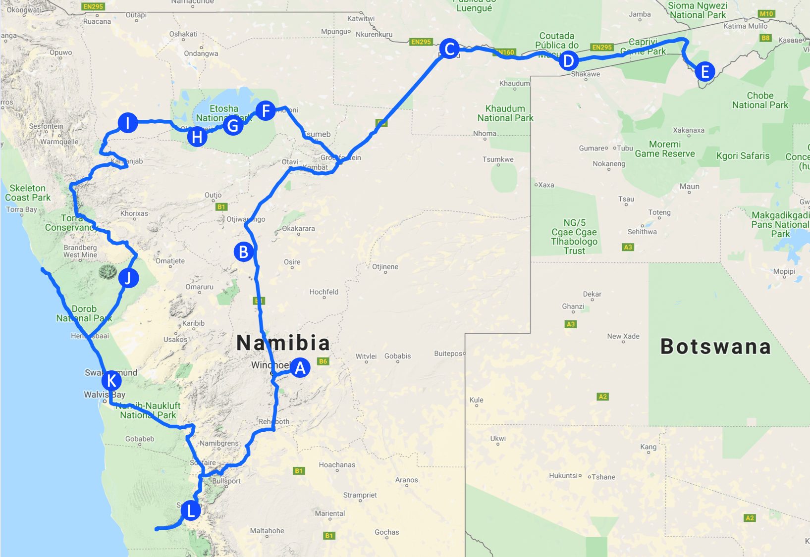
This trip included most of the normal tourist destinations in Namibia like Etosha National Park, Sossusvlei and Swakopmund. But Namibia has a lot more to offer and so we went off the beaten path all the way to the Caprivi strip and only recently opened areas of Etosha. Overall the trip took a bit over three weeks, of which 20 were actually enjoying this beautiful country. The rest was the very long and tiring flight. Getting from southern California to Windhoeck required stops in London and Johannesburg and took a total of about 36 hrs each way. It was well worth it. We drove 4830 km (3019 mi) and came back with over 90 GB worth of photos and videos.
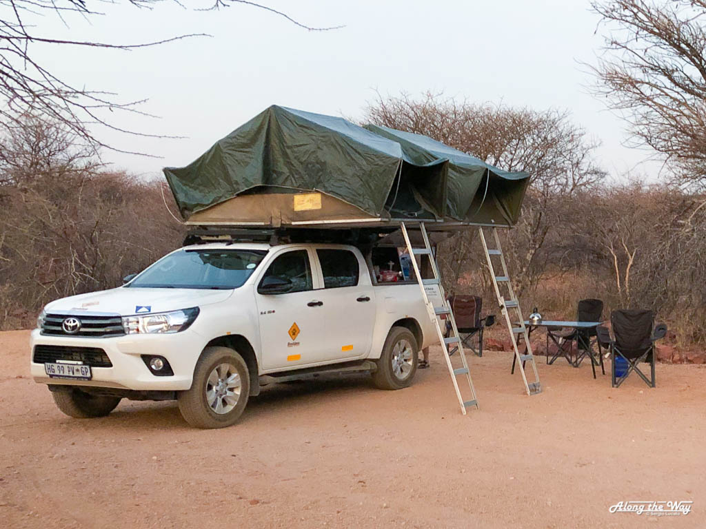 Unlike my previous excursions to Africa, this trip was a self-drive trip in a slightly modified Toyota Hilux from Bushlore. It had two fold out tents on top which were surprisingly roomy, stable and, most importantly, comfortable. The back had a large drawer with all the kitchen tools, pots and pants as well as a fridge/freezer. The latter did indeed freeze quite well as we discovered the painful way after my beer became frozen solid. A few adjustments resulted in a better experience. The car itself is a solid 4×4 performer with a locking rear differential. Both are essential to successfully navigate the more remote areas.
Namibia in general is ideally set up to drive by yourself. It has a very good network of gas stations throughout, most of which accept credit cards. The road system is for the most part well maintained, although that varies with the commercial importance of the region. However, even the worst gravel road is signposted. It is almost impossible to get lost as long as you have a decent map.
Days 1 – 4: Windhoeck to Rundu
The adventure started right away after the long hours en-route to Windhoeck. The car company picked us up from the airport and proceeded to provide an hour long introduction into the various aspects of the Hilux we had rented. I do quite a bit of off-roading in the Mojave desert near where I live so this part was fairly easy. Driving this truck on the left hand side through rush hour Windhoeck on the other hand was less so. Especially considering that I do not have any muscle memory for the manual transmission in my left hand. In the end we made it to our first base, the Trans Kalahri Inn (A), and were able to enjoy and nice cold beer and the first of many unbelievable sunsets in Namibia.
The next day started off with acquiring provisions and Money. The Superspar near the Maerua mall is convenient as the mall next door also offers an easy point to exchange money. Few banks will exchange money in Africa, something I suffered from on other trips. With the car fully loaded up, the trip started in earnest going to the Okonjima Nature Reserve (B) which was to become home for the next two days and nights. The latter should not be overlooked. With almost no light pollution, the night sky is breathtaking.
Okonjima is home of The AfriCat Foundation. This foundation rescues and rehabilitates carnivores throughout Namibia. The Okonjima location houses leopards and cheetahs, some of which we would get to see during our stay. The reserve itself offers a couple nice hikes as well as the opportunity to visit the AfriCat Foundation. All of the hikes are inside a large fenced in area and thus safe from predators. It is a great introduction into the local flora and very much worth it. The reserve also does the obligatory game drives and the more interesting leopard tracking. Personally, I found the tour of the AfriCat Foundation and vet clinic the most rewarding of all options. If offers a great insight into the dangers these large cats face in today’s Namibia. Of course the visit ends with a tour of the resident leopard and cheetahs. Even though they are in a fenced in enclosure, it does appear zoo like.


The first part of the trip concluded with the longest drive of the trip going up to Rundu at the Angolan border. Fortunately, the B1 is tarred and in excellent condition. Unfortunately, the fridge in our truck decided to give up. The prospect of warm beer did not sit very well with me. Being the engineer I am, I started to disassemble the battery wiring of the car. Here is a little bit of background on cars that are upgraded for these types of trips: They have two batteries. One for the engine and a second one for the fridge and auxiliary lights. The two of them were connected through a rather ingenious piece of electronics, the Electronic Battery Isolator. This thing is supposed to connect the two batteries while the motor is running and disconnect them when still to prevent the main battery from being discharged by the fridge. In between is a large 100 A fuse that protects this gizmo. It was broken and thus the second battery did not charge. That fuse is not easy to get to and has no window to show its status like normal car fuses have. Long story short, I removed all the wires, checked them with a 12 V light I had and was able to patch it. In the end all was good. The fridge worked again, the car still worked, I had no parts left over and none missing, and most importantly, had cold beer again.
Rundu, at long last, is a rather drab city. It is the main gateway to the Caprivi strip that runs between Botswana and Angola. As such there is a lot of truck and passenger activity going to all the neighboring countries. It is the last opportunity to load up on groceries before heading east. While Rundu has a few decent lodges and places to stay overnight, it is hardly a destination in itself. I chose the Camp Hogo Kavango (C), located right on the Kavango river, to rest for the night. The bar is located right on the river with some of the most beautiful sunsets anywhere.


Days 5 – 9: The Caprivi Strip
The Caprivi strip, as Wikipedia informs named after German Chancellor Leo von Caprivi, is a long thin land strip running between Botswana and Angola, almost reaching Zimbabwe. I have been to the Botswana side many years ago and was amazed by the animals drawn to the water here. The rivers flow year round and the landscape is unusually green and lush compared to the rest of Namibia. Especially this year since the last rainy season essentially did not happen. However, even here the lack of rain has left its mark with many normally full channels being completely dry. It was a theme we would see many more times this trip.
The trip along the strip was divided into two locations, the Popa Falls and Bwabwata National Park on the western end and Nkasa Rupara National Park on the eastern end. Popa Falls are the shallow waterfalls the Kavango river goes over before flowing into Botswana to become the famous Okavango delta. There are two accessible areas of the Bwabwata National Park that lines the Kavango river. On the western bank lies the Mahango Core Area and the eastern bank houses the Buffalo Core Area. The rest of the park is not accessible other than driving along the B8 autoroute that runs the entire length of the Caprivi Strip.
The morning of day 5 was spend shopping in Rundu to load up on supplies for the coming days. So we arrived late at the Popa Falls Resort (D) run by Namibia Wildlife Resorts, the state owned company managing accommodations in the national parks. The resort is located right by the falls and has a nice deck from which to enjoy the sunset overlooking the falls. While it is certainly very relaxing to enjoy a cold beer there, the falls are really more of a set of slow rapids. Anyone expecting something along the scale of the Victoria Falls will be very disappointed.
The wildlife on the other hand is everything but disappointing. Both the Mahango and Buffalo core ares are easily accessible by car and very much worth it. A 4×4 does help as there are a couple sandy stretches. Otherwise, the resort, like all others, offers a 3 hrs game viewing drive. 3 Hrs on each side is plenty to see everything there is to see as the road only runs a couple kilometers to the Botswana border. The Caprivi strip is about the only area in Namibia were one can see hippos. There is just not enough water elsewhere in the country. Besides the hippos, all the park has an abundance of all the other animals one expects to see in Africa, Elephants, Giraffes, Zebras and of course as the name would suggest, Buffalos. For those interested in history, there are old military installations from times past.


When planning this trip, I was somewhat exited at the possibility of driving the B8 through the park and seeing all the animals. This road did not deliver on that hope, though. It did however offer a good insight in how the locals live in this part of the country. For that it was interesting to drive along here. And since I am at the topic of the local population, there is stark difference between this part of Namibia and the usual tourist paths between Swakopmund and Etosha. There are comparably few tourists in this area and as such the people do not pay a lot of attention to the random white guy showing up. Whereas elsewhere I was immediately swarmed by people trying to sell stuff and asking for money.
For anyone looking to have a national park to oneself, Nkasa Rupara is a dream come true. This park is essentially a flood plane of the Linyanti and Kwando rivers that border it. It is criss-crossed by channels and mud and sand planes. Quite a few of the roads running through the park require some more advanced 4×4 skills to use. And that is if the road can even be found. On many occasions we had to double back because a road simply did not exist anymore as a new channel had formed where the road used to be. However, that also led us to discover a lot more of the park than we would have otherwise seen. It was a thoroughly enjoyable experience. There are 3 camps in the park, two tented lodges and one small campground, the Nkasa Rupara Restcamp (E), in which we stayed. It is fairly small with only 7 spots and rudimentary facilities. It also came with one crazy Hornbill that clearly had lost a couple marbles along the way.


After two days in this beautiful part, it was time to move on by retreating all the way back to Rundu with another stop at the Popa Falls Resort. The goal was the famous Etosha National Park some 900 km (560 mi) away. However, before we got there I had to learn the hard way why all the cars come with two spare tires. On our way out of the park I drove over a dead acacia twig. Anyone who has seen these things before will know what came next. A 5 cm (2 in) long thorn bored into the front tire. Fortunately there are no lions in this park as I had to spend some quality time in the dirt to change and fix the tire.
Days 10 – 15: Etosha National Park
When most people think of a safari in Namibia, it will invariably be Etosha National Park. The Park is centered around the large Etosha salt pan which in the past used to be the only accessible part of the Park. Pretty much everything in this National Park is enormous. The park itself, the size of the animal herds and the size of the human herds which are being brought in literally by the busloads. It was a stark difference from Nkasa Rupara with its almost lush greens and utmost lack of humans. Etosha is dry, very dry. Especially due to the lack of rains in the past years. While there are a couple natural waterholes, most are artificial with a bore and solar pump. They were made not only for the sake of the humans visiting, but also to draw large animals away from the surrounding farmlands.
Etosha has three main lodging locations. From east to west these are Namutoni with its fort, Halali at the center and Okaukuejo at the west. Until a couple years ago the western half of the park with its mountainous terrain was closed to tourists. It is now open and has one more campground, Olifantsrus. The line separating the main, eastern part of the park from the newly opened western part also separates the park into mass tourism in the east from the calm in the west. Unlike the camp in Nkasa Rupara, all the campsites are surrounded by an electric fence with the main gates closing at sunset and reopening at sunrise. This is to protect the humans from predators, but adds a distinct zoo-like feel to it. All camps also have an illuminated waterhole with stadium seating to safely see the animals at night.
We drove the entire length, or rather width, of the park staying at all four campsites. We spend one night each at Namutoni (F), Halali (G) and Okaukuejo (H), and two nights at Olifantsrus (I) using the day to drive every available road from one camp to another. There are not a lot of roads available and off-roading is strictly prohibited. That results in a constant, insane traffic on all roads which distracts quite a bit from the overall experience. Another quirk of the mass-tourism at Etosha manifests itself every morning at about 6 am. All guides state that the best times to see animals is early morning and late afternoon when the temperatures are more agreeable. And so, every morning, dozens of diesel powered buses and trucks take off in search of whatever walks and crawls. Not only is it impossible to sleep in a bit, but the whole camp sounds and feels worse than a highway during rush-hour.
The first day we drove around Namutoni in search of lions of which there are supposed to be around 200 in the park. The search for lions became a constant and futile endeavor for a while. What we lacked in lions we saw in all other animals. In that regard Etosha does not disappoint. My personal favorite was a little elephant having fun and blowing bubbles in a waterhole. Overall, the region around Namutoni is marked mostly by the salt pan with a rather featureless landscape. Namutoni camp itself is rather large and features the old fort prominently. The campsite is also home to a large group of Banded mongoose which are a lot fun as long as they do not steal ones breakfast.


Halali camp is a bit further remote from the pan in a forested region of the park. Although with the lack of rains, the forrest is suffering and not a lot trees have any leafs left. There are supposed to be a couple rhinos in this area, but we did not encounter any. With this area also being far from any water sources we did not see many animals in general until we got closer to Okaukuejo. Okaukuejo at the western end of the salt pan is the largest of the camps and the main entrance for most visitors. It had the largest waterhole of the three camps and offered a beautiful sunset with various animals.


The next day we departed for the newly opened western half of the park. As soon as we left behind the main road out of the park Etosha returned to wild and empty. The single road from Okaukuejo to Olifantsrus is a steady slow climb away from the salt pan to the more mountainous region of the park. And here we were finally lucky and saw our first lions. It was already noon by the time we encountered them and thus they were more interested in what little shade there was to be found to what cats to best: sleep.
The next 80 km (50 mi) of road were almost desert with only the occasional little remnant trees. I fear that if Namibia does not get significant rains in the coming years, most of the park will become like this. Global warming is having catastrophic effects and this region bears the brunt of it. These days the only water in the vast region of Etosha is found at the artificial waterholes. They all consist of a solar powered pump feeding a swallow concrete pool. The overflow then feeds a natural dirt pool below. While animals keep their distance from one another in the natural pools further east, they all cluster in huge impressive herds around here.


Olifantsrus camp is the newest and smallest of the camps and features only 10 sites for single cars. Like the other sites, it has an artificial waterhole with viewing platform. However, here they build a small house next to the waterhole outside the fence and connected it to camp by an elevated walkway. This allows for much closer view of the animals which is very impressive. Especially when herds of elephants come by to drink and get a mud-bath.
We stayed at this camp for two nights to be able to drive the last of the roads further west of the camp. Here, the park transforms into a mountainous terrain with tall acacia trees. It is quite different from the lower elevations and we got the see the first of the red sand which is so prominently featured further south. After another gorgeous sunset and star studded night, it was time leave the park and make our way to the Skeleton coast. But before we finally left, we were rewarded by another group of lions with the most impressive male so far.


Days 16 – 17: Skeleton Coast
There are two ways to get from the Dalton Gate at the west end of Etosha to Swakopmund. The first first goes by Palmwag and includes almost the whole drivable length of the Skeleton Coast. The second runs through the interior to the old mining town of Uis and then turns toward the ocean. We first planed to take the former, but then in the last minute decided to drive by Twyfelfontein to see a bit more variety. I was hoping to have enough time to maybe see the petroglyphs at Twyfelfontein.
That was not to happen. Turns out that our map had the road marked as asphalt, but in reality it was all gravel and sand. Worse yet, most of it was in terribly washboarded condition. Travel was slow and painful, both mentally and physically. The landscape was beautiful, though. First passing through the Grootberg pass and then through the desert valley dotted with oasis in which Twyfelfontein is located. If we had one more day, stopping in Twyfelfontein would have made all the difference. But hindsight is 20/20 and we had to be in Swakopmund the next day. I also wanted to drive at least a little bit of the Skeleton Coast to view the seal colony there.


Uis is a small town next to a now defunct tin mine. Closing the mine dealt a devastating blow to the community. Today the town is little more than a refueling stop between Swakopmund and Etosha and the north. The old leisure facility with a huge pool has been converted into the Brandberg Rest Camp (J) in which we stayed. The hot shower and ice cold draft beer helped undo the damage from the road. A ginormous burger from the restaurant helped a well for sure. Unfortunately, the washboard also did a number on one of our tents as one of the main brackets broke.
The next morning we drove to the coast and were amazed at the difference 100 km (60 mi) makes to the temperatures. It was freezing cold wind coming in from the ocean while we had endured 40 ºC (104 ºF) just before. The roads at least did change for the better with the old gravel washboard giving way to a nice salt road. They use salt brine to bind the dirt and it makes a rock hard surface almost like concrete. We made good use of that road looking for two things the Skeleton Coast is famous for: Ship wrecks and seals.
Turns out there are not a lot of wrecks still visible, safe for a recent Angolan fish trawler that is now a bird heaven. The seals on the other hand were abundant at the Cape Cross seal reserve. There were thousands of them all over the place. Many had pubs and were still nursing. The sounds and smells were overwhelming, but seeing them up close is amazing. The seals are so accustomed to humans that many will let you touch them. I can now understand why people used to like fur coats. They are very soft and cuddly.


As the day was drawing to a close we arrived in our first hotel in over 2 weeks. After eating pasta for most of the trip, the prospect of a real meal, a real bed and a real shower was awesome. We decided to stay right in the middle of the old city at the Secret Garden Guesthouse (K), which I can highly recommend. Swakopmund is nice, but an odd city overall. It is a German city transplanted into the desert and just does not really seem to fit in. It is also a huge tourist hub with buses upon buses of tourists descending on every available restaurant. Strolling around town and watching the sunset over the pier was a nice break from the arid climate elsewhere.


Days 18 – 20: Sossusvlei
After a bountiful breakfast we returned inland on our way to the last stop of this trip. The red dunes and dead trees of Sossusvlei are maybe the most famous and visited destination in Namibia. I have seen pictures of Dead Vlei and had wanted to visit for a long time. All I can say in short is that this place is mesmerizing. We stayed at the NWR campground at Sesriem (L) at the end of the regular road and entrance to the park. The camp itself is nice and conveniently located, but that is also its biggest drawback. Just like in Etosha all the guides state that sunrise is the time to be in the park and so, at 5 am, the diesel caravan takes off with all the noise and commotion that comes along with it. We did not experience a sunrise, but I can confidently say that sunset is marvelous and you have the park to yourself.
Sossusvlei itself is another 60 km down the only road after which the nice asphalt turns into deep, soft sand. There are two options. Park your car the end of the road and have the park shuttle take you in to see the main attraction or put the car into 4×4 and master the sand yourself. The latter is not very difficult, but definitely requires true 4-wheel drive and high clearance. This part absolutely not doable in a normal car.
Sossusvlei has four major stops along the way. First one is the aptly named “Dune 45”, located 45 km (28 mi) along the road. This is one big dune and everyone crawls up along the spine. The second stop, Hidden Vlei, is at the end of the asphalt road by the parking lot. It is called that because in order to see it one has to hike 2.5 km (1.6 mi) over soft dunes to get there. Take enough water and start at the wooden sign. The path is not well marked, though. Once you cross the little forest, look slightly to the left and there will be rods in the ground. Follow them and you will be rewarded with an empty desert and have Hidden Vlei all to yourself. It is worth it! The next stop is about 4 km (2.5 mi) along that soft sand road. Sossusvlei, all the way at the end, has a couple nice shaded picnic benches. Otherwise, sadly, I did not quite see the appeal of the namesake of this park.
For me Dead Vlei, shortly before Sossusvlei, is the true marvel of the whole park. The photos with the dead trees in front of red dunes are all from Dead Vlei. It is just a short, easy hike of about 1.1 km (0.7 mi) away. For a desert-lover like me, this place is breathtakingly beautiful, almost spiritual. Make sure to get there about 1.5 – 2 hrs before sunset and you will be rewarded with shaded red dunes and the long shadows that amplify the otherworldly experience. And as all the tour buses have left to drop their human load off at Dune 45, you will again have this all to yourself. Although in my case I had a small hawk or falcon to accompany me. If you really feel adventurous, you can climb up Big Daddy, a huge dune at the far end of the vlei. I did not, but I am sure the views must be gorgeous.


Remarkably, even in this most arid of all regions, there is an abundance of animals. We have seen lots of Oryx and antelopes all over and even the occasional jackal. After a couple hours of taking it all in, it was time to return to camp.
Next morning we went to the Sesriem canyon after which the area and camp are named. It is nice little slot canyon with a water hole at the end. One hour is about all it takes to see it. Just avoid the early afternoon as that is when all the buses arrive.
Finally, the last day had come around and we made our way back to Windhoeck. We had to return the car and exchange the hiking clothes of the past 3 weeks for a more civilized attire. That last day was bittersweet. A cold beer, nice steak and comfortable bed awaited at the end of the long road back. However, it also meant that I had to trade the beauty of Namibia in for the sights and comfort of 36 hrs in airports and airplanes.
Final Words
We spend 20 days in this beautiful country full of amazing signs and experiences. The people are genuinely friendly, helpful and proud to show off their country. Namibia is very safe. Even the folks trying to sell trinkets or asking for money were not very pushy. Other countries are far worse in that regard. At no time did I ever feel threatened or uncomfortable.
Self driving is very easy and allowed us to do things at our own pace. The fully equipped rental car is not cheap and a no-frills bus tour might come in lower. But then you do not have the peace we had. Namibia is also quite popular. We tried to do this trip a year before but did not allow enough time to book everything. In the end we booked all the major stops in December for a September trip.
If you are ever thinking about visiting Africa, Namibia is an easy introduction. Go ahead, but be warned. If the Africa bug bites, you might just have to come back for more.
P.S. Since I talked a lot about a cold beer, I recommend the Windhoek Draught beer.

As you mention, Namibia must be one of the best countries to visit for an African travel introduction. It is easy and there are so much to see. South Africa is more hectic and you still don’t need to worry about many of the hazards in other parts of subsaharan Africa. 🙂
LikeLike